Artist Turns Vintage Gas Station Maps into a Dystopian Future Underwater
2025-04-22
Author: Emily
Reimagining the Past for a Warming Future
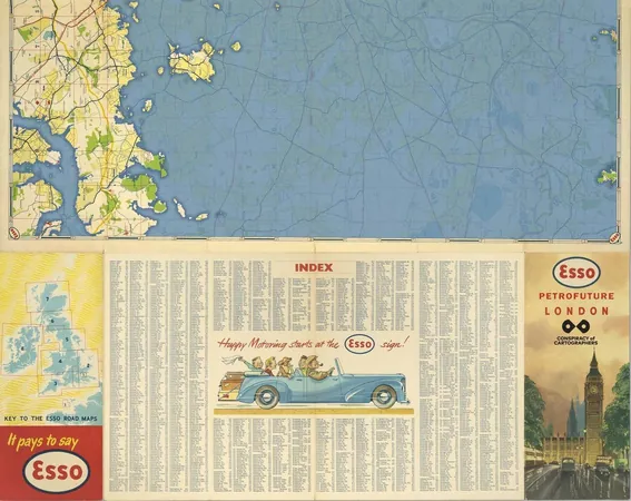
In a stunning blend of art and activism, Seattle-based cartographer Jeffrey Linn is transforming old gas station maps into chilling visualizations of what our planet might look like under the weight of climate change. His imaginative works, part of the 'Petrofuture' series, illustrate a world where coastal cities and river plains are swallowed by rising seas, victims of the melting polar ice caps and glaciers.
A Visual Protest Against Fossil Fuels
Linn's groundbreaking approach utilizes maps that originated from oil companies, which once encouraged rampant car use and fossil fuel consumption. By overhauling these vintage visuals, he brilliantly flips the narrative, showcasing the dire consequences of unchecked emissions—extensive flooding in urban areas.
Art Meets Legal Strategy
To protect his work legally, Linn cleverly incorporates the logos of major oil companies like Shell and Esso while also adding his own logo. "An IP attorney advised me that adding my own logo turns these maps into editorial pieces, granting them legal protection under parody law," Linn notes.
Mapping the Unthinkable: A Flooded Future
Utilizing Geographic Information System (GIS) software, Linn overlays dramatic sea level rise predictions onto the maps. His projections include a staggering 66 meters of sea level increase—the worst-case scenario forecasted by the Intergovernmental Panel on Climate Change (IPCC). While total ice sheet melting is a long way off, Linn highlights that the early signs of flooding could be felt within decades.
From Nostalgia to Reality
“These maps were given away free at gas stations as advertising—pure propaganda. My reinterpretations serve as a form of anti-propaganda,” Linn explains. He aims to counter the millions spent by petrol corporations in greenwashing tactics while reminding us of their environmental impact.
What Lies Beneath?
Linn's maps reveal a staggering fate for cities across North America and beyond. Central Seattle and Vancouver could transform into scattered islands, while Los Angeles would become a vast bay, water inundating its sprawling plains. Even major U.S. cities like New York and Boston face grim futures, with significant portions likely to disappear.
A Global Perspective
While Linn primarily works with North American maps, he has crafted versions depicting flooded versions of European cities such as London and Paris, demonstrating that no corner of the globe is safe from the potential devastation of climate change.
The Urgency of Climate Action
Organizations like Climate Central emphasize the pressing reality of rising sea levels. Their updates highlight that by 2050, land currently inhabited by 300 million people is at risk of becoming submerged. These projections reinforce the need for immediate action against climate change.
Imagining the Inevitable
As Linn reflects on the importance of these visual warnings, he acknowledges the difficulty many have in grasping long-term consequences. "Although we may struggle to conceptualize the distant future, history shows us that significant change can occur much quicker than we expect. Just 450 years separate us from the Tudor period, and dramatic flooding could likewise unfold in our lifetimes," he asserts.
A Call to Action
Linn, who works as a transit map designer by day, emphasizes that while he isn't a climate scientist, the urgency of the data available cannot be ignored. As global warming accelerates and sea levels rise, we must confront this reality head-on and work collectively to alter the course of our environmental future.


 Brasil (PT)
 Canada (EN)
 Chile (ES)
 Česko (CS)
 대한민국 (KO)
 España (ES)
 France (FR)
 Hong Kong (EN)
 Italia (IT)
 日本 (JA)
 Magyarország (HU)
 Norge (NO)
 Polska (PL)
 Schweiz (DE)
 Singapore (EN)
 Sverige (SV)
 Suomi (FI)
 Türkiye (TR)
 الإمارات العربية المتحدة (AR)