Brace for Impact: An Atmospheric River Storm Set to Pummel the Northeast with Ferocious Winds and Torrential Rain
2024-12-11
Author: Emma
Powerful Storm Set to Impact Northeast
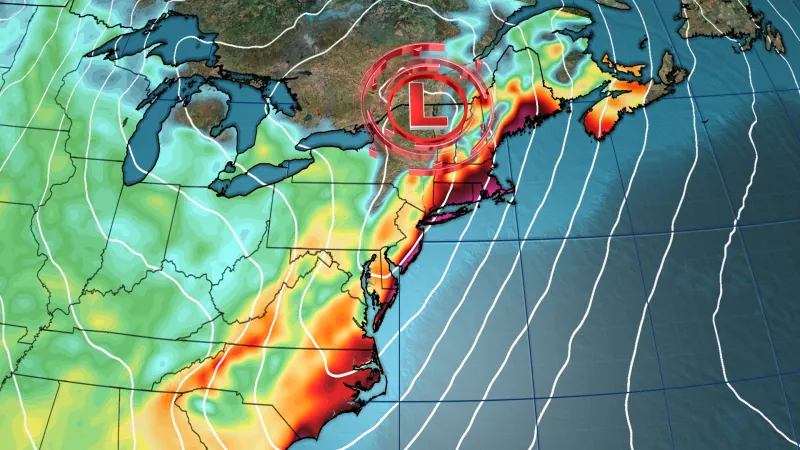
As the East Coast braces itself for a powerful storm empowered by an atmospheric river, Wednesday's forecast indicates a deluge of heavy rain and fierce winds that are only expected to intensify throughout the day.
Forecasted Conditions
The Northeast is poised to experience the storm’s worst conditions, leading to hazardous travel and challenging outdoor situations. Wind gusts reaching up to 60 mph later in the day threaten widespread power outages across major cities, including New York City and Boston.
Authorities from the National Weather Service in Boston have issued stark warnings: "Damaging winds could uproot trees and down power lines. Be prepared for potential widespread power outages. Travel will be particularly challenging for larger vehicles, such as buses and trucks."
Atmospheric River Phenomenon
What makes this storm exceptional is the sheer amount of moisture it has absorbed from the warm tropical waters off the Southeast coast. This rare atmospheric river phenomenon is expected to unleash rainfall rates that can lead to flash flooding—a forecast of immense concern for communities still reeling from previous weather events. Experts point out that this will be the most moisture-laden weather system to affect the Northeast since last December when devastating floods claimed lives and damaged infrastructure across several states, including Maine.
Drought Relief and Flooding Risks
Many areas in the Mid-Atlantic and Northeast haven't seen a significant rainfall event since August, making this storm a much-needed reprieve from ongoing drought conditions, notably severe in New Jersey where extreme dryness has particularly set in. Although the ground can absorb some of the rain, forecasters caution that urban areas with poor drainage could face hazardous flooding and water pooling on roads.
In Philadelphia, rainfall has not exceeded one inch in a single day since August 6, while New York’s Central Park last experienced a two-inch rainfall event on August 18. Despite this, projections indicate that this storm could quickly deliver substantial rainfall, with the risk of flooding rated at level 2 of 4 stretching from Long Island, New York, northward to Maine, and some regions potentially receiving between 2 to 4 inches of rain.
Flash Flooding Risks in New England
Rapid snowmelt in parts of interior New England further escalates the flash flooding risk, particularly near creeks and low-lying areas. According to the Weather Prediction Center, however, communities in New England might be somewhat cushioned by their ability to handle increased moisture after an unexpectedly dry fall.
Thunderstorm Risks in the Mid-Atlantic
Further south, residents in parts of the Mid-Atlantic could face thunderstorms, categorized by a level 2 of 5 risk for severe storms, particularly along the coast from eastern North Carolina up to southern New England. While damaging winds remain the primary threat from these storms, forecasters cannot rule out the possibility of tornadoes in eastern North Carolina.
Post-Storm Weather Changes
After this chaotic weather system passes, another wave of Arctic air will sweep across the region, bringing temperatures back down below seasonal averages. Wind chills will plummet to below zero in parts of the Northern Plains and the Midwest by Wednesday morning. Lake effect snow is also projected to ramp up in the Great Lakes, with accumulations of 1 to 2 feet possible by the end of the week.
Conclusion
Stay alert and take necessary precautions as this intense storm approaches!


 Brasil (PT)
 Canada (EN)
 Chile (ES)
 España (ES)
 France (FR)
 Hong Kong (EN)
 Italia (IT)
 日本 (JA)
 Magyarország (HU)
 Norge (NO)
 Polska (PL)
 Schweiz (DE)
 Singapore (EN)
 Sverige (SV)
 Suomi (FI)
 Türkiye (TR)