Brace for Impact: Another Weather Bomb Targets British Columbia This Friday!
2024-11-22
Author: Liam
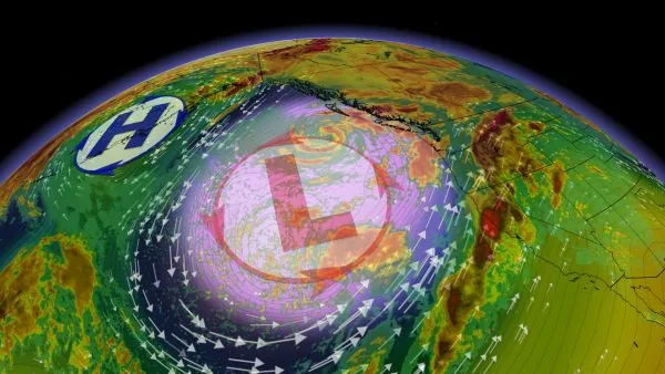
Get ready, British Columbia! A powerful storm is set to unleash strong winds, torrential rain, and significant mountain snow as a second bomb cyclone forms off the coast this Friday.
This impending weather system is the second round of a relentless atmospheric setup that has been battering the region. While this storm will be less intense than the bomb cyclone that hit earlier this week, it still poses a serious threat, with high wind gusts and heavy precipitation expected.
What to Expect: Power Outages and Travel Disruptions
Residents should prepare for potential disruptions to power and travel during Friday and Saturday as winds pick up and rain pours down. This storm is expected to cause widespread impacts, so staying informed through local weather warnings is crucial.
The remnants of the previous bomb cyclone are retreating offshore, but they are contributing to the development of this new low-pressure system. This time, moisture is being funneled off an atmospheric river from the northwestern United States, set to saturate B.C.'s South Coast by Friday.
Despite being a weaker system, this cyclone is still likely to meet the criteria for rapid intensification, making it a bomb cyclone in its own right. The storm is anticipated to move closer to the coastline than its predecessor, amplifying its effects.
High Winds and Heavy Rainfall Predicted
The most significant hazard from this new system is severe winds. Southerly gusts are expected to flow through the Strait of Georgia, with speeds of 50-70 km/h recorded in Vancouver and even stronger gusts reaching up to 80-100 km/h in Victoria. Western Vancouver Island may experience power outages as gusts could be particularly fierce in that region.
As this is the fourth significant storm event in just a few weeks, we may see less widespread power outages this time, as damaged trees and weaker foliage have already been stripped away by previous gales. However, ferry services could once again be affected, although delays might not be as severe.
In terms of rainfall, this storm will be more extensive, advancing inland across southern B.C. Forecasters predict rainfall totals of 15-30 mm for the Lower Mainland and 5-10 mm for Victoria. Snowfall in the mountains might be less than expected due to the less organized moisture.
Stay Safe and Prepared!
As British Columbia braces for yet another storm, it's essential for residents to take precautions and stay updated on the latest weather developments. This ongoing sequence of weather bombs serves as a reminder of the power of nature and the importance of preparedness in the face of extreme weather. Don’t get caught unawares—make sure you’re ready for whatever Mother Nature throws your way!


 Brasil (PT)
 Canada (EN)
 Chile (ES)
 España (ES)
 France (FR)
 Hong Kong (EN)
 Italia (IT)
 日本 (JA)
 Magyarország (HU)
 Norge (NO)
 Polska (PL)
 Schweiz (DE)
 Singapore (EN)
 Sverige (SV)
 Suomi (FI)
 Türkiye (TR)