Canada Welcomes Its First Tornado of 2025: A Surprising Spring Phenomenon!
2025-04-13
Author: Michael
A First for Canada in 2025
April is barely halfway through, and Canada has already recorded its first tornado of the year! Following a torrent of severe weather south of the border, it was only a matter of time before the storm system crossed into Canadian territory.
Alberta's Unexpected Twister
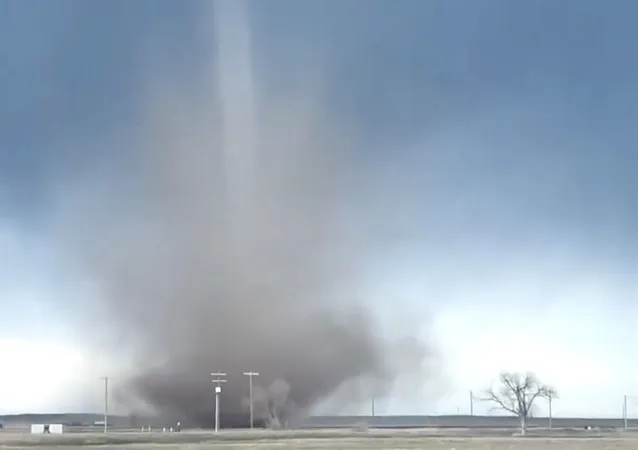
On Saturday, April 12, Alberta earned the honor of hosting the country's inaugural tornado of 2025. Interestingly, this event unfolded while other regions in the province were still grappling with snowy conditions.
What Kind of Tornado Was It?
The twister, identified as a landspout tornado, made its appearance northwest of Rolling Hills around 5:20 p.m. MDT. Captured in both photos and videos, the tornado quickly garnered attention before being officially confirmed by Environment and Climate Change Canada (ECCC). Although it received multiple eyewitness reports and images, thankfully, no damage has been reported.
Understanding the Landspout Tornado
Given a preliminary EF-0 rating, this landspout tornado was characterized by weak rotation beneath rapidly developing clouds or weak thunderstorms. According to ECCC, while these tornadoes typically don’t wreak havoc, they can still be dangerous enough to uproot trees and damage roofs.
Weather Conditions at Play
The conditions on Saturday weren't typical for a powerful tornado formation; instead, they displayed a unique blend of Alberta's unpredictable weather. Cool air aloft combined with surface heating led to a quick temperature drop as you ascend.
Although the Convective Available Potential Energy (CAPE) was low—just a couple hundred joules—this is common in early spring setups. The tornado likely formed along a convergence zone, giving rise to a visible funnel amid rapidly rising air.
Landspout vs. Supercell Tornadoes
What distinguishes a landspout from a more powerful supercell tornado? Landspouts don’t spring from rotating supercells. Instead, they emerge from convergence points or outflow boundaries and usually possess a weaker rating (EF-0 or EF-1). But don’t let that fool you; even a weaker tornado can pack a punch! Picture a mini tornado spiraling like a dancer speeding up by pulling in her arms—that’s the power of atmospheric lift!
What’s Next?
With spring underway, Canadians can expect more weather surprises as temperatures rise and storms become more common. Will Alberta see more twisters this season? Only time will tell!


 Brasil (PT)
 Canada (EN)
 Chile (ES)
 Česko (CS)
 대한민국 (KO)
 España (ES)
 France (FR)
 Hong Kong (EN)
 Italia (IT)
 日本 (JA)
 Magyarország (HU)
 Norge (NO)
 Polska (PL)
 Schweiz (DE)
 Singapore (EN)
 Sverige (SV)
 Suomi (FI)
 Türkiye (TR)
 الإمارات العربية المتحدة (AR)