Revolutionary Approach Combines AI and Ecology to Slash Animal-Vehicle Collisions
2024-12-20
Author: Emily
Introduction
Animal-vehicle collisions pose a serious risk to wildlife conservation and public safety while incurring significant costs for transport authorities. However, innovative research from France is set to change the game in managing these potentially dangerous encounters.
Research Methodology
A dedicated team led by researchers Sylvain Moulherat and Léa Pautrel from OïkoLab and TerrOïko has devised a groundbreaking strategy that utilizes a network of camera traps, advanced AI, and ecological modeling to map and manage collision risks between trains and large mammals, particularly roe deer and wild boar.
Utilization of Technology
With the proliferation of sensors integrated into transport infrastructures, this research taps into their potential by creating digital twins of these environments. The first step of this pioneering method involves simulating animal movements in and around transport corridors using ecological modeling software. This approach allows the researchers to pinpoint the most likely crossing points for these animals.
Identifying Collision Hotspots
After identifying collision hotspots, the team employs ecological modeling once again to strategize the placement of photo sensors in the field. Different deployment scenarios are tested through simulations, ensuring that the optimal configuration aligns closely with initial movement predictions.
Data Processing and Analysis
Once the sensors are operational, the captured images are analyzed using deep learning algorithms, allowing for the detection and identification of species near the infrastructure. This integration of artificial intelligence enhances the accuracy and efficiency of data processing.
Mapping Species Abundance
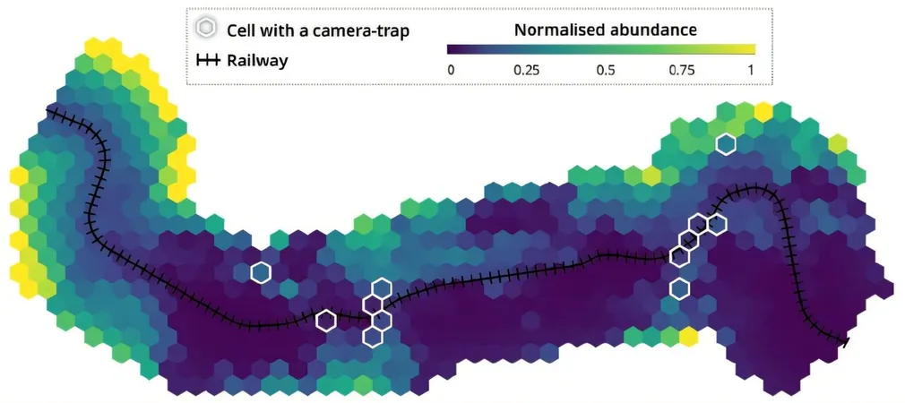
The final piece of the puzzle involves feeding the processed data into an abundance model. This ecological model estimates the potential density of animal populations across the region based on the information gathered from strategically placed sensors. The outcome is a comprehensive map illustrating species abundance and corresponding collision risks along transport routes.
Field Trials and Future Applications
This innovative approach has already been trialed on a railway segment in southwestern France, demonstrating its feasibility. Moreover, the methodology shows promise for application across various transport infrastructures—existing ones as well as those in the design phase. Crucially, this approach can be integrated into environmental impact assessments, paving the way for more wildlife-friendly transportation solutions.
Conclusion
As traffic fatalities involving wildlife continue to rise, the introduction of such advanced methodologies is not just timely; it is essential for safeguarding both animal populations and human lives on the road. Will this new tech usher in a safer era for roadways plagued by animal crossings? Only time will tell, but the results so far are promising.


 Brasil (PT)
 Canada (EN)
 Chile (ES)
 España (ES)
 France (FR)
 Hong Kong (EN)
 Italia (IT)
 日本 (JA)
 Magyarország (HU)
 Norge (NO)
 Polska (PL)
 Schweiz (DE)
 Singapore (EN)
 Sverige (SV)
 Suomi (FI)
 Türkiye (TR)