Revolutionary Satellite Technology Transforms Seafloor Mapping!
2024-12-13
Author: Sophie
Revolutionary Satellite Technology Transforms Seafloor Mapping!
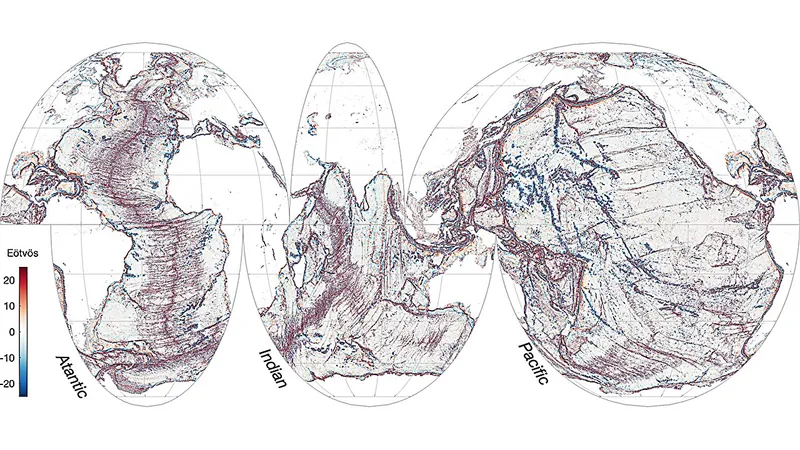
In a groundbreaking new study published in *Science*, researchers reveal that the Surface Water and Ocean Topography (SWOT) mission has dramatically enhanced our ability to map the seafloor using satellite technology. This unprecedented data could unlock secrets about ocean biodiversity, plate tectonics, and even tsunami behavior.
Traditionally, vessels using sonar have only been able to achieve a resolution of approximately 200–400 meters (650–1,300 feet) when mapping the ocean floor. As part of the Seabed 2030 initiative, there is a goal to map the entire seafloor by the end of this decade. However, this labor-intensive and costly process has managed to cover merely 25% of the ocean floor thus far.
The majority of existing seafloor maps have relied on satellite altimetry, which captures variations in ocean surface height. Scientists interpret this data to infer the underlying features that play significant roles in marine gravity. For instance, sea levels are typically elevated above underwater mountains known as seamounts. Over the last 30 years, altimetry data has provided a resolution of about 12–16 kilometers (7.5–9.9 miles), but the SWOT mission takes this a step further. Launched in 2022 as a collaboration between NASA and the French space agency CNES, SWOT measures sea surface height in two dimensions, allowing for far more detailed measurements.
Using data from SWOT collected between April 2023 and July 2024, researchers have achieved an astonishing resolution of 8 kilometers (5 miles) for mapping marine gravity. Yao Yu, the lead author of the study and a postdoctoral researcher at the Scripps Institution of Oceanography, stated, "One year of SWOT data surpasses the previous 30 years of traditional nadir altimeter data in constructing marine gravity."
This enhanced resolution has yielded the discovery of thousands of small seamounts and has allowed researchers to characterize abyssal hills and accurately map submarine canyons. Identifying these features can significantly advance studies on ocean circulation and deep-ocean mixing, which are critical to understanding global ocean temperatures and the ocean's ability to absorb carbon dioxide.
Industry experts are equally impressed. Ole Baltazar Andersen, a geophysicist at the Technical University of Denmark, proclaimed that the ability to map abyssal hills and seamounts with such clarity represents a significant advancement in our mapping capabilities of Earth. Meanwhile, Nadya Vinogradova Shiffer, an ocean physicist at NASA and a SWOT program scientist, praised the work as not just "impressive," but revolutionary, indicating that it opens up new frontiers in fields like geodesy, ocean modeling, hydrology, navigation, and benthic ecology.
As we look forward to the future of oceanographic research, this development marks a thrilling new chapter in our quest to understand the hidden realms of our planet’s oceans. Stay tuned for more groundbreaking discoveries!


 Brasil (PT)
 Canada (EN)
 Chile (ES)
 España (ES)
 France (FR)
 Hong Kong (EN)
 Italia (IT)
 日本 (JA)
 Magyarország (HU)
 Norge (NO)
 Polska (PL)
 Schweiz (DE)
 Singapore (EN)
 Sverige (SV)
 Suomi (FI)
 Türkiye (TR)