Unveiling Earth’s Secrets: The Revolutionary Impact of Satellite Science on Environmental Research
2024-12-11
Author: Amelia
Introduction
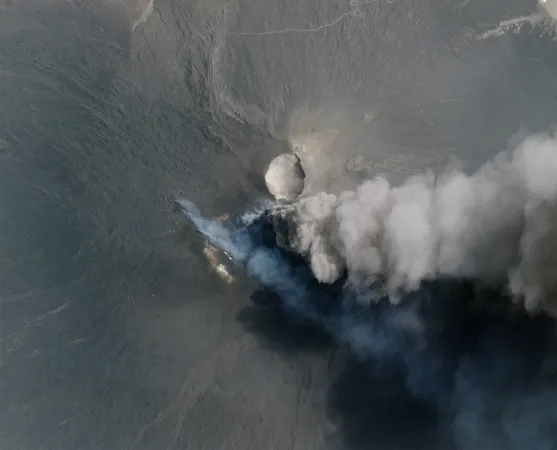
Satellites may not ponder philosophical dilemmas, but they are crucial in answering pressing scientific questions about our planet. Earth observation (EO) satellites have become essential tools for scientists seeking to understand complex environmental systems. Their efforts have uncovered significant phenomena, including the alarming collapse of Thwaites Glacier in Antarctica, the explosive eruption of Hunga Tonga-Hunga Ha'apai, and even unique insights into penguin populations through the analysis of their excrement.
The Economic Value of Satellite Data
As our reliance on scientific understanding deepens, the role of satellite data has only expanded. NASA's Landsat program, for instance, generated an estimated $25.6 billion in value in 2022, illustrating just how vital EO satellites are in connecting local events to larger environmental shifts. This figure is a mere fraction of the total economic and ecological benefits fairing into our understanding of climate change and natural resource management.
Planet Labs and High-Resolution Datasets
Planet Labs, a leading player in the space of satellite imaging, enhances both governmental research initiatives and academic projects through its extensive high-resolution datasets. Their database not only captures snapshots of our planet but also offers a year-over-year archive, allowing researchers to uncover historical trends that inform future projections.
Main Discoveries from Satellite Imagery
Exciting recent discoveries demonstrate the profound implications that satellite imagery can yield. In a dramatic incident in September 2023, a massive landslide in Greenland occurred as a 1,200-meter peak collapsed, with its supporting glacier melting away. This calamity generated a tsunami towering at 200 meters, producing seismic waves that rippled through the Earth for nine days—an event unlike conventional earthquakes, which only last for minutes to hours. Insights gleaned from Planet's images have stirred urgent discussions regarding the link between Arctic melting and global warming.
Satellite Technology in Archaeology
In the realm of archaeology, innovative techniques are ushering in a new frontier, sometimes even referred to as "4D Archaeology." Researchers have successfully leveraged Planet's multispectral datasets to discover lost civilizations previously obscured by dense forests. For example, a recent PhD student's remarkable achievement used Lidar technology to uncover a hidden Mayan city in a remote area of Mexico. This represents a significant shift in archaeological methodologies, prioritizing satellite technology over traditional excavation techniques.
Indicators of Environmental Distress in Alaska
Alaska's rivers have become alarming indicators of environmental distress, changing from blue to a disturbing orange. New findings reveal that thawing permafrost is introducing toxic metals such as iron and copper into waterways, with satellite data pinpointing the onset of this phenomenon around 2017 and 2018—coinciding with record-breaking temperature highs.
Waste Management Innovations
The issue of waste management is another arena where satellite technology is making waves. By analyzing satellite imagery, research from Duke University has demonstrated how machine learning algorithms can effectively identify locations where waste is being burned, a process that releases hazardous pollutants. This data can aid in creating more effective strategies to combat pollution at municipal levels.
Monitoring Fragile Ecosystems
Moreover, satellites have become indispensable in monitoring some of the most fragile ecosystems on Earth, such as Antarctica, where researchers observe changes in vegetation and the alarming retreat of glaciers. These insights play a critical role in preparing for potential sudden flooding events caused by destabilizing ice-dam lakes, threatening communities in high-risk areas.
Understanding Forest Dynamics
The importance of healthy forest ecosystems cannot be overstated, and satellite technology allows for an accurate understanding of forest dynamics. Planet's Forest Carbon product consistently delivers data on forest carbon levels, tree heights, and canopy coverage, providing a clearer picture of how global forests are evolving.
Innovative Agricultural Studies
In the realm of agriculture, innovative studies, including one focused on Cambodia's substantial cashew industry, leverage high-quality satellite data to map land use patterns. Incorporating data from PlanetScope, Sentinel-1 & 2, and Landsat imagery, this research aims to optimize agricultural practices while minimizing ecological impacts.
Tracking Invasive Species
Lastly, the invasive Rosa rugosa plant has emerged as a thorny issue for Estonia’s coastline ecosystem. Initially introduced as an ornamental species, its aggressive expansion is now outcompeting native flora. Researchers at the Estonian University of Life Sciences are utilizing both drones and PlanetScope satellite data to monitor and map the spread of this invasive species, aiding in targeted eradication efforts.
Conclusion
With each satellite image, we unveil more of Earth's mysteries, solidifying the connection between human activities and environmental changes—underscoring the urgent need for sustainable stewardship of our planet. Don’t miss out on this fascinating intersection of technology and nature—subscribe for more updates!


 Brasil (PT)
 Canada (EN)
 Chile (ES)
 España (ES)
 France (FR)
 Hong Kong (EN)
 Italia (IT)
 日本 (JA)
 Magyarország (HU)
 Norge (NO)
 Polska (PL)
 Schweiz (DE)
 Singapore (EN)
 Sverige (SV)
 Suomi (FI)
 Türkiye (TR)