Dive Deep: Stunning Animation Unravels the Secrets of the Ocean Floor!
2025-03-21
Author: Jia
In an incredible breakthrough for oceanography, NASA has unveiled a new ultra-detailed map of the seafloor, providing a clearer view of the ocean depths than ever before. This transformative imagery is the result of advanced observations from space, thanks to the Surface Water and Ocean Topography (SWOT) satellite, launched in 2022 in collaboration with France's CNES space agency.
Historically, the moon has been mapped more extensively than our planet’s underwater realms. However, the recent data generated by SWOT promises to change that narrative. Just a year post-launch, researchers have made waves in scientific journals, like the notable publication in Science, showcasing an astonishing new seafloor map.
What makes this map so remarkable is its resolution and the scope of data it provides. The SWOT satellite effectively fills significant information gaps that have long hindered our understanding of the ocean’s floor. With its abilities, it offers a crystal-clear view that not only aids researchers but also enhances safety for submarines navigating through these previously enigmatic landscapes. Furthermore, this technology plays a crucial role in managing the installation and repair of vital underwater telecommunications cables, keeping global communication lines intact.
NASA's recent video adds a visual kick to this scientific endeavor, showcasing mesmerizing animation of the seafloor terrains off the coasts of Mexico, South America, and the Antarctic Peninsula. As research utilizing SWOT data progresses, more stunning revelations about the ocean's deep, dark secrets are on the horizon.
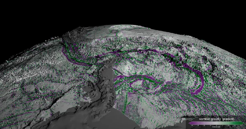
The mapping methods employed by SWOT leverage gravity-based data, exposing previously hidden features of the ocean landscape. The satellite detects subtle gravitational variations, revealing the rolling abyssal hills and towering undersea volcanoes, known as seamounts, that shape our ocean floors. “We were surprised that SWOT could see them so well,” stated oceanographer Yao Yu from the Scripps Institution of Oceanography, the lead author of the groundbreaking paper in Science. This newfound knowledge has revealed that these hills, often formed where tectonic plates diverge, actually cover about 70 percent of the ocean floor, making them Earth's most prevalent landform.
While ships equipped with sonar can also chart these abyssal regions, the process is painstaking and time-consuming. Currently, only a fraction—around 25%—of the world’s ocean floor has been mapped using traditional methods. SWOT stands to revolutionize this approach with its high-speed and comprehensive data collection capabilities.
Beyond mapping the seafloor, SWOT's primary mission remains to meticulously measure water heights over various bodies of water, including oceans, rivers, and lakes. This ambitious initiative aims to deliver the first ever complete survey of Earth's surface water, enhancing our understanding of climate patterns and water resources as global challenges intensify.
With the future of ocean exploration looking brighter than ever, stay tuned for more exciting discoveries and revolutionary insights from the depths of our planet's oceans!


 Brasil (PT)
 Canada (EN)
 Chile (ES)
 Česko (CS)
 대한민국 (KO)
 España (ES)
 France (FR)
 Hong Kong (EN)
 Italia (IT)
 日本 (JA)
 Magyarország (HU)
 Norge (NO)
 Polska (PL)
 Schweiz (DE)
 Singapore (EN)
 Sverige (SV)
 Suomi (FI)
 Türkiye (TR)
 الإمارات العربية المتحدة (AR)