Tropical Storm John Powers Up Again – Mexico Braces for Impact!
2024-09-26
Author: Ting
Tropical Storm John Gains Strength
Tropical Storm John is making headlines once more as it gains strength over the Pacific Ocean, with a forecasted upgrade to hurricane status before it strikes the Mexican coast. This comes just after the storm wreaked havoc earlier in the week, resulting in the tragic loss of at least two lives.
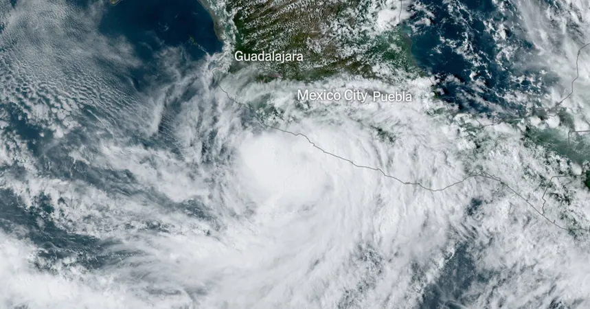
Landfall Forecast
According to the National Hurricane Center, John is expected to make landfall tonight near the city of Lázaro Cárdenas in southwestern Mexico. This will be the second time this week that the storm has made landfall. Residents along the coast are under a hurricane warning, indicating that hurricane conditions could arrive within 36 hours. Meanwhile, a tropical storm watch is in effect for areas northward, as safety preparations accelerate.
Previous Impact of the Storm
Earlier in the week, John escalated rapidly from a tropical storm to a formidable Category 3 hurricane, with maximum sustained winds of 120 miles per hour. After hitting land, the storm weakened but left substantial rainfall across some of Mexico’s poorest states, Guerrero and Oaxaca, leading to flash flooding and landslides. By Tuesday, over 10 inches of rain had already been recorded, and authorities expect up to 20 more inches to fall as the storm continues its path toward the coast.
Warnings of Catastrophic Flooding
The devastating rains are expected to trigger "catastrophic, life-threatening flash flooding and mudslides" across four states on Mexico’s Pacific coast. In a plea for safety, President Andrés Manuel López Obrador urged citizens in affected areas to "seek higher ground" and prioritize their safety above all material concerns.
Local Impact and Infrastructure Damage
Evelyn Salgado, the Governor of Guerrero, reported that the storm had a profound impact on her state, leading to landslides that resulted in fatalities in Tlacoachistlahuaca. The aftermath has left approximately 60,000 residents without power, with fallen trees obstructing critical roadways.
Climate Change Connection
In an alarming trend, a recent study highlighted that rapid storm intensification, as observed with John, is now twice as likely due to human-induced climate change and the increasing temperatures of ocean waters.
Unique Meteorological Phenomenon
Interestingly, while John continues to impact Mexico, it shares a unique connection with Hurricane Helene swirling in the Gulf of Mexico—both storms originated from the same meteorological phenomenon known as the Central American gyre. This connection is expected to amplify Helene into an even more powerful force as it approaches Florida.
Urgent Need for Preparedness
As these storms demonstrate the escalating intensity associated with climate change, the urgency for preparedness and infrastructure resilience in vulnerable regions has never been clearer. Stay tuned for more updates as Tropical Storm John approaches Mexico, and keep safe if you are in its path!


 Brasil (PT)
 Canada (EN)
 Chile (ES)
 España (ES)
 France (FR)
 Hong Kong (EN)
 Italia (IT)
 日本 (JA)
 Magyarország (HU)
 Norge (NO)
 Polska (PL)
 Schweiz (DE)
 Singapore (EN)
 Sverige (SV)
 Suomi (FI)
 Türkiye (TR)