Unveiling the Crisis: How Satellite Data Confirms Climate Change is a Global Emergency
2024-10-05
Introduction
As we embark on 2024, the climate crisis has reached staggering new heights, and the facts are chilling. July saw Earth endure its highest average temperature in over 175 years, with July 22 marking the hottest day ever recorded. This summer was not just an anomaly; it established itself as the warmest since 1880. Adding to the alarming trends, this year's hurricane season kicked off with Hurricane Beryl, the earliest recorded Category 4 hurricane, and a June report confirmed that human-driven global warming has reached unprecedented levels.
The Stakes Are High
However, the threat goes beyond just record-breaking temperatures and storms. Glaciers are melting at alarming rates, causing sea levels to rise irreversibly. Coastal communities are facing more destructive storms, worsened by this increased sea level, which leads to dire consequences for both humans and wildlife. The recent devastation wreaked by Hurricane Helene reminds us of the realities of our warming planet, with its intensity being directly linked to climate change.
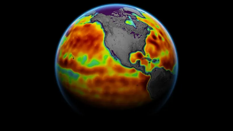
The Role of Satellite Data
Despite the dire statistics, there is a crucial element: the availability of satellite data. This information is vital for transforming hard facts into impactful actions, particularly in convincing policymakers to prioritize the climate crisis. The political nuances surrounding this issue underline a stark truth: the future of our planet hinges on our ability to interpret and act on the data—which, surprisingly, often comes from an astronomical source: satellite technology.
According to Cedric David, a scientist at NASA's Jet Propulsion Laboratory (JPL), "The only way we can draw connections between the various phenomena that drive the complex functioning of our planet is to connect the dots among them." He emphasizes the need for an ongoing fleet of "space sentinels" tasked with diagnosing our planet's health, similar to how we routinely check our own health.
What Do Climate Satellites Do?
Satellites, in essence, are objects placed into Earth's orbit, fulfilling various essential roles. Beyond communications and navigation, climate satellites hold a particular significance. They are instrumental in understanding the dynamics of our own planet. For instance, satellites equipped with spectrometers measure atmospheric carbon dioxide concentrations, revealing a troubling spike primarily due to fossil fuel consumption. This heightened greenhouse gas effect has a direct correlation with rising global temperatures.
NASA's Landsat satellites provide critical imagery to assess deforestation, monitor changing ecosystems, and observe forced wildlife migrations—an alarming indicator of climate change's impact on biodiversity. Additionally, satellites with laser technology measure ice cap melting rates, while synthetic aperture radars monitor how our planet reacts to natural disasters like earthquakes.
One of the most groundbreaking tools in this arsenal is gravimetry, a method that allows scientists to measure subtle changes in Earth's gravitational field. This technique helps identify ice mass losses linked to both global warming and rising ocean levels, thereby providing insights into fluctuations in groundwater supplies—information that is simply "mind-blowing," as David describes it.
Earth's Future is Our Future
The vast array of data generated by climate satellites plays a critical role in equipping scientists with the evidence needed to push for meaningful changes. During high-profile climate conferences—such as the United Nations’ COP meetings—this data offers concrete support for policy proposals aimed at addressing climate change.
Immediate applications of satellite data can drastically improve our response to natural disasters. Meteorologists rely on these satellites to predict hurricane paths and intensities, essential for safeguarding communities from increasingly violent storms. Methane trackers help locate greenhouse gas hotspots, giving us crucial information in our efforts to mitigate climate impacts.
In a 2018 report, the U.S. National Academies recommended developing an Earth System Observatory (ESO), a series of spacecraft designed to monitor climatic and geological changes. Yet, significant gaps remain in our knowledge. David highlights the challenge of measuring snowpacks from space, which is vital for water resources in many regions, including California.
Overall, David believes that all facets of this satellite data contribute immensely to our understanding—a critical tool in formulating effective strategies to combat climate change. He cites radar altimetry as particularly invaluable, providing undeniable evidence of rising sea levels, stating, “The 30-year-long curves of sea level rise are unquestionable evidence that our climate is changing.”
Conclusion
As the alarming evidence continues to mount, one thing becomes painfully clear: climate change is real, it is driven by human activities, and our response must be dictated by this ever-continuing stream of satellite data. Cedric David succinctly reminds us, "So far, the only place where we have found life is right here on Earth." We can endlessly search for alternatives, but the imperative remains: we must take action to protect our only home.

 Brasil (PT)
 Canada (EN)
 Chile (ES)
 España (ES)
 France (FR)
 Hong Kong (EN)
 Italia (IT)
 日本 (JA)
 Magyarország (HU)
 Norge (NO)
 Polska (PL)
 Schweiz (DE)
 Singapore (EN)
 Sverige (SV)
 Suomi (FI)
 Türkiye (TR)