BepiColombo's Revolutionary Flyby of Mercury Unveils Volcanic Plains and Crater Mysteries!
2024-12-19
Author: Daniel
Introduction
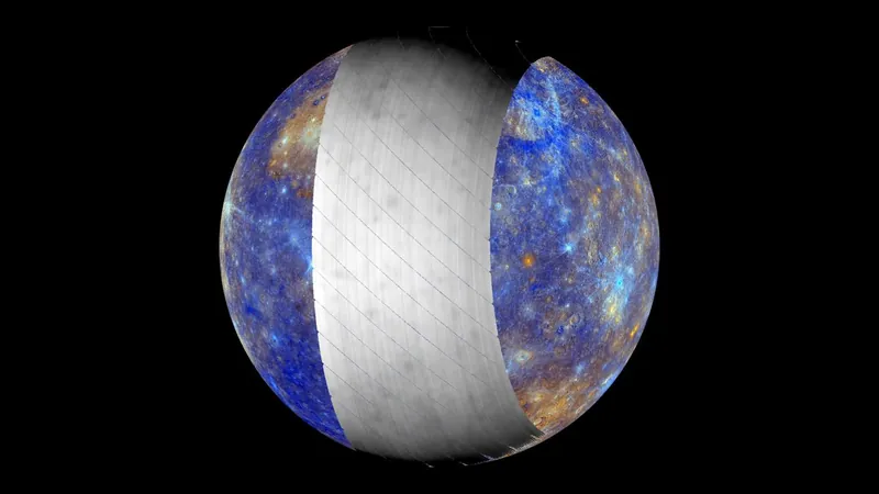
In a groundbreaking event for planetary science, the BepiColombo spacecraft has once again revolutionized our understanding of Mercury. This past December, during its fifth flyby of the innermost planet in our solar system, BepiColombo utilized its Mercury Radiometer and Thermal Infrared Spectrometer (MERTIS) to capture stunning images of Mercury in the elusive mid-infrared spectrum.
First Observations of Mercury's Surface
For the first time, scientists were able to observe Mercury’s surface in mid-infrared wavelengths, offering unprecedented insights into the planet’s geology. Mid-infrared light, although invisible to the naked eye, provides crucial information about the mineral composition and thermal properties of extremely hot rocks. The December 1 flyby, which took place at an altitude of approximately 37,626 kilometers (23,400 miles), has now paved the way for future discoveries as the mission progresses.
BepiColombo's Flight Path
BepiColombo's journey to Mercury has seen it execute a series of intricate maneuvers. The spacecraft's closest encounter so far occurred on September 4, when it zipped just 165 kilometers (about 103 miles) above Mercury's scorched surface. The mission is set to finalize its intricate trajectory with an additional flyby planned for January 2025, before officially entering orbit around Mercury in late 2026.
Analyzing Mercury’s Surface Composition
During the flybys, researchers not only gather vital scientific data but also validate the spacecraft's instruments. One pressing mystery scientists are keen to unravel is the precise composition of Mercury’s surface. The MERTIS instrument is integral to this investigation, as many minerals emit strong mid-infrared signals when heated, allowing researchers to compare this data against their pre-established mineral database.
Laboratory Preparations and Findings
As part of their preparations, the MERTIS science team has conducted extensive laboratory tests. They heated various mineral combinations to over 400 degrees Celsius (752 degrees Fahrenheit) to build a comprehensive database of their mid-infrared emissions, essentially creating unique thermal fingerprints for these materials.
Unexpected Results
Interestingly, the findings from this flyby revealed that Mercury's surface is unexpectedly low in iron. Solmaz Adeli, project lead from the German Aerospace Center, emphasized the need for alternative mineral simulations to understand the planet’s composition better.
Detailed Imaging and Geological Features
The latest imaging covered a significant portion of Mercury's northern hemisphere, detailing features such as a vast volcanic plain and the Caloris Basin—a massive rocky formation nestled within a colossal impact crater. Observations also included the Bashō Crater, previously imaged by earlier missions, enhancing our collective knowledge of these geological structures.
Conclusion and Future Prospects
“The moment we first analyzed the MERTIS flyby data and recognized the distinctiveness of impact craters was exhilarating!” exclaimed Adeli. “This dataset holds endless discoveries, featuring surface attributes that have never been explored in this manner before.” Despite the distance of over 37,600 kilometers during the flyby yielding a resolution of 26 to 30 kilometers (approximately 16 to 19 miles), the information gathered was enough for researchers to begin understanding Mercury's complex geological narrative. Once BepiColombo achieves a stable orbit, MERTIS is expected to provide high-resolution imaging at a breathtaking scale of 500 meters (547 yards), potentially unlocking more secrets about our solar system's enigmatic inner planet. Stay tuned as we continue to follow BepiColombo’s journey and delve deeper into the mysteries of Mercury!


 Brasil (PT)
 Canada (EN)
 Chile (ES)
 España (ES)
 France (FR)
 Hong Kong (EN)
 Italia (IT)
 日本 (JA)
 Magyarország (HU)
 Norge (NO)
 Polska (PL)
 Schweiz (DE)
 Singapore (EN)
 Sverige (SV)
 Suomi (FI)
 Türkiye (TR)