Unleashing Smart Robots: How LiDAR Technology is Revolutionizing Disaster Response!
2025-01-02
Author: Siti
Unleashing Smart Robots: How LiDAR Technology is Revolutionizing Disaster Response!
In a groundbreaking development, researchers from the prestigious Fraunhofer Institute for Communication, Information Processing and Ergonomics FKIE are harnessing LiDAR (Light Detection and Ranging) technology to create a mobile robot capable of exploring perilous, unfamiliar terrains such as disaster-stricken chemical plants or flood-hit areas. This innovative robot emits laser pulses to generate precise 3D models of its environment, empowering emergency responders to assess dangerous situations without putting themselves at risk.
The Role of LiDAR in Emergency Situations
In critical situations—whether a hazardous chemical leak or unforeseen flooding—emergency services require immediate situational awareness. However, entering these areas can pose significant dangers to personnel. Enter the 3D-InAus project, an initiative aimed at transforming disaster response. Timo Röhling, the project’s technical manager, emphasizes the advantages of LiDAR over traditional camera-based systems, stating, “Our approach outstrips existing technology by providing accurate measurements that facilitate precision 3D mapping, capturing distances and dimensions down to mere centimeters.”
How the Technology Works
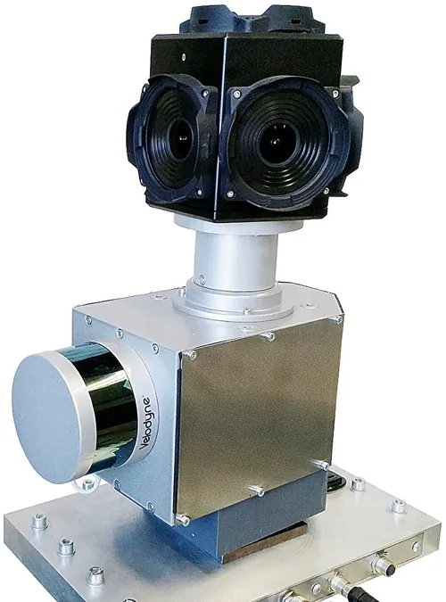
At the heart of this innovative solution lies a LiDAR laser mounted on a rotating turntable. This sophisticated setup scans an area comprising 16 vertical sections ten times per second, delivering a staggering 1.3 million laser pulses per second. These pulses bounce back from surrounding objects, with their time of travel allowing researchers to calculate exact distances. The mobile robot can operate in continuous motion or stop-and-go mode, generating a 3D point cloud of the environment that essentially acts as a high-resolution digital blueprint.
Enhancements with Camera Integration
But that’s not all! The system also incorporates a camera array, including up to six cameras, which assists in providing vivid color to the 3D representations. Röhling elaborates, “By merging camera images with point cloud data, we create dynamic and geometrically precise visualizations of buildings, open spaces, and various objects.” Imagine the incredible clarity this offers to emergency responders needing to make split-second decisions!
Speed and Efficiency
What’s even more impressive is the speed with which this technology works. The robot can map an area of 400 x 400 meters in just three hours. However, in time-critical situations, rapid operation modes can yield preliminary overviews in as little as one hour. With the potential for multiple robots to operate simultaneously, large areas can be surveyed quickly and efficiently.
Military Applications and Sensor Integration
Notably, this 3D mapping technology is also being leveraged by the Bundeswehr (German Armed Forces), enhancing situational awareness in unpredictable environments and significantly contributing to service member safety. The software is designed to integrate data from additional sensors that detect toxic gases or radiation, placing these hazardous readings directly on the 3D maps.
Navigating Indoor Environments
Navigating inside buildings presents its own set of challenges, primarily due to the lack of GPS signals. However, the researchers have ingeniously tackled this issue. Using prior knowledge of a building’s position and size—gathered through exterior mapping—the system can create a ‘virtual GPS’ to autonomously navigate indoors.
Development and Versatility
The development team at Fraunhofer FKIE, drawing from their extensive experience in 3D modeling and robotic systems, meticulously crafted this cutting-edge technology. They engineered the concept, selected the appropriate components, and formulated the algorithms responsible for the robot's operation.
A Testament to Innovation
Versatility is a core feature of this robotic system, with the LiDAR module and turntable designed for compatibility with a wide range of vehicles. Depending on the specific deployment scenario, options include wheeled vehicles, tracks, or even drones—truly a testament to the innovative spirit and adaptability of modern robotic solutions!
The Future of Crisis Response
Stay tuned as this pioneering technology reshapes how we respond to crises, potentially saving lives with every deployment!

 Brasil (PT)
 Canada (EN)
 Chile (ES)
 Česko (CS)
 대한민국 (KO)
 España (ES)
 France (FR)
 Hong Kong (EN)
 Italia (IT)
 日本 (JA)
 Magyarország (HU)
 Norge (NO)
 Polska (PL)
 Schweiz (DE)
 Singapore (EN)
 Sverige (SV)
 Suomi (FI)
 Türkiye (TR)
 الإمارات العربية المتحدة (AR)