Unveiling the Mysteries of an Undersea Landscape Shaped by Volcanoes and Glaciers
2024-12-21
Author: Li
Introduction
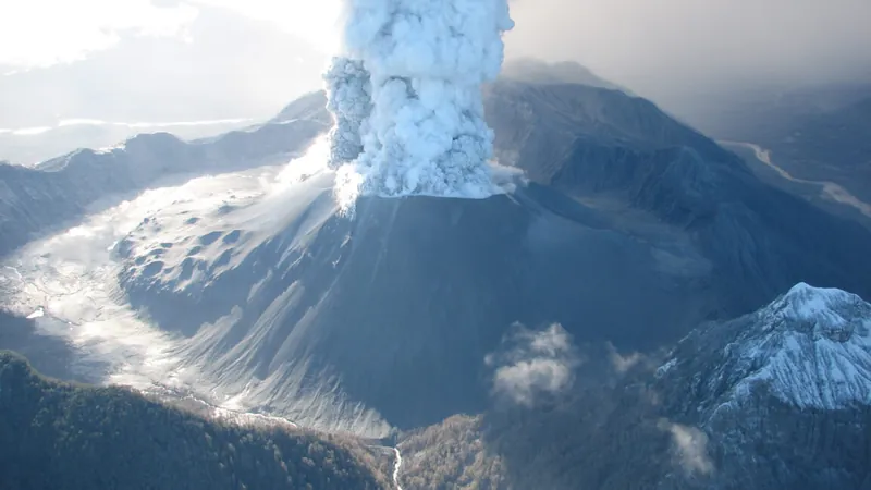
In a stunning geological revelation, the Chaitén volcano in Chile erupted violently on May 2, 2008, after a staggering 9,000 years of silence. The eruption unleashed a torrent of ash and rock, launching debris over 12 miles into the atmosphere. Following the initial chaos, torrential rainfall triggered massive mudflows that devastated the town of Chaitén, effectively splitting it in two, while ash spread ominously across over 200,000 square kilometers of land.
Environmental Impact
While the destruction on land was vividly captured by media and satellites, the consequences for the marine environment remained a mystery—until now.
There is an astounding statistic worth noting: the Chaitén eruption released more than 750 billion liters of lava, enough to fill a staggering 300,000 Olympic-sized swimming pools. Much of this volcanic material found its way to the Northern Patagonian Sea, a mere six miles from the eruption site.
Research Expedition
In September, an international team of scientists, aboard the Schmidt Ocean Institute’s research vessel Falkor (too), embarked on a gripping mission to explore the flow of volcanic ash and its far-reaching effects. Their expedition led to the discovery of an underwater valley that has astonishingly remained unchanged since glaciers receded approximately 17,000 years ago.
Objectives of the Research
The primary aim of the research was to witness firsthand how underwater ecosystems are influenced by volcanic phenomena. Dr. Sebastian Watt, the expedition's chief scientist and an associate professor of Earth Sciences at the University of Birmingham, stated, “Our observations will provide insights into how active volcanoes affect marine environments and infrastructure, including fisheries and communication cables.”
Although the rural location of Chaitén lacks submarine cables, the knowledge gained will be crucial in assessing the implications of volcanic activity on similar infrastructures in coastal and island regions globally.
Underwater Investigations
Despite the frequent occurrence of volcanoes near oceans, the thorough investigation of their impact on marine ecosystems has largely been overlooked. Dr. Watt emphasized that the data collected could illuminate the range of hazards that coastal communities face after eruptions.
The team utilized a remotely operated vehicle (ROV), affectionately called SuBastian, to capture footage of the ocean floor where volcanic material was deposited. With sophisticated cameras, lights, and sensors, this technological marvel enabled researchers to collect samples from locations deemed otherwise unreachable.
Sample Collection and Analysis
Rodrigo Fernández, an assistant professor at the Universidad de Chile, remarked, "The ability to visually identify and select our sampling sites is a game changer. Traditionally, we rely on indirect data to target sampling sites, but with the ROV, we can make more informed decisions.”
The samples obtained encompass sediment and biological remains, which researchers will analyze to trace the timeline of the area’s ecological dynamics before and after the eruption. This comparison will shed light on how the volcanic event transformed the marine ecosystem.
3D Mapping and Geological Insights
While SuBastian illuminated its immediate surroundings, sonar technology helped produce a high-resolution 3D map of the seafloor. This mapping unveiled "mega-dunes" formed of volcanic ash, colossal formations that reveal insights into the geological processes at play.
Spanning over 1,000 square miles, the mapping effort even went as deep as 15 miles from the volcano, uncovering layers of ash and sediment. Unique coring devices were employed to extract sediment samples from the ocean floor, preserving crucial evidence of geological and biological activity in the area.
Historical Significance of Sediment Layers
Interestingly, sediment layers are often better preserved underwater than on land, providing a clearer historical record that can reveal intricate details of past life and events. With sediment dating back over 15,000 years in some areas, scientists plan to employ radiocarbon dating and other techniques to create a robust timeline of geological history.
Ecological Discoveries
The diversity of life and sediment types sampled throughout their survey revealed surprising insights about marine life before and after the eruption. Alastair Hodgetts, a physical volcanologist and geologist from the University of Edinburgh, noted, “The oldest site we explored revealed a fossilized seascape that was completely unexpected.”
The team’s examination of seismic data along with sediment layers offers a fresh perspective on the area's geological timeline. Giulia Matilde Ferrante, a geophysicist at Italy's National Institute of Oceanography, remarked, "Reconstructing the past will allow us to understand sediment history and landscape changes more deeply."
Future Research Directions
With vast quantities of sediment from the eruption recorded, researchers are now posed with the task of investigating whether older layers hold records of similar volcanic events that remain undocumented.
Gaining a foothold on the procedures of prehistoric volcanic eruptions is crucial for future preparedness. “Understanding the frequency and impact of past eruptions equips us to mitigate risks for local communities in future events,” Dr. Watt concluded.
Conclusion
This groundbreaking research offers not only a glimpse into history but also a pathway for communities to better navigate and respond to volcanic threats in the future, ushering in a new era of geological exploration and understanding.


 Brasil (PT)
 Canada (EN)
 Chile (ES)
 España (ES)
 France (FR)
 Hong Kong (EN)
 Italia (IT)
 日本 (JA)
 Magyarország (HU)
 Norge (NO)
 Polska (PL)
 Schweiz (DE)
 Singapore (EN)
 Sverige (SV)
 Suomi (FI)
 Türkiye (TR)