Groundbreaking Discovery: Satellites Unveil Detailed Maps of Earth’s Hidden Ocean Floors!
2024-12-12
Author: Benjamin
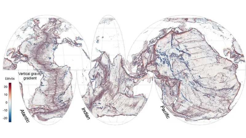
In a stunning advancement in oceanographic research, a new NASA satellite has meticulously mapped the Earth's ocean floors like never before. The Surface Water and Ocean Topography (SWOT) mission, launched in December 2022 as a joint venture between NASA and France's Centre National D'Études Spatiales, has achieved a monumental milestone in understanding our planet’s underwater landscapes.
This innovative satellite has provided researchers with the first year of unprecedented measurements, allowing them to delve deep into the hidden world of oceanic features that conventional satellites have missed. Thanks to the detailed data from SWOT, scientists can now draw the boundaries between continents and pinpoint small underwater hills and volcanoes that were previously undetectable.
Yao Yu, a physical geographer with the Scripps Institution of Oceanography and co-author of the study, expressed excitement over these findings, stating, “Finding these features will really push scientific developments forward, including tectonic theories.” This breakthrough could unfold new insights into ocean currents, nutrient transport in seawater, and the overall geological history of Earth’s oceans.
What makes this satellite so extraordinary? With a resolution of 5 miles (8 kilometers) and a coverage path that spans most of the globe every 21 days, the data collected in just one year from SWOT has provided clearer insights into the ocean floor than 30 years of collective information from ships and older satellites. This remarkable efficiency is shaking up the way scientists study oceanic processes.
SWOT operates by measuring variations in ocean surface height, revealing the underlying topography of the seabed. Contrary to popular belief, the ocean's surface is not a flat expanse; instead, the gravitational pull from underwater features like hills and volcanoes creates undulations and elevations in sea level. These variations point to the incredible features hidden beneath the ocean's surface.
The research team concentrated on three primary types of underwater structures: abyssal hills, small seamounts, and continental margins. Abyssal hills—parallel ridges formed by tectonic plate movements—are generally only a few hundred feet tall. Utilizing the SWOT data, the researchers identified distinct hills and even observed shifts in the ridges' directions, indicating past tectonic movements that shaped our oceanic landscape.
“I’m very surprised by the abyssal hills,” Yu conveyed, noting that the team was not anticipating to uncover such a multitude of these formations in such a short time.
Moreover, the researchers also explored seamounts, underwater volcanoes that play a significant role in influencing ocean currents and are often biodiversity hotspots. While previous satellite missions successfully mapped larger seamounts, SWOT has brilliantly detected thousands of previously unknown seamounts, each measuring less than 3,300 feet (1,000 meters) in height.
This groundbreaking data has refined existing maps of tectonic boundaries and ocean currents, especially near coastal areas. “We’re very interested in continental margins because ocean currents and tides transport nutrients and sediments from land to sea, which deeply influences biodiversity and ecological health in coastal zones,” Yu added.
In summary, SWOT is not merely a satellite; it is a gateway to understanding our planet’s oceans like never before. This pivotal research is set to revolutionize marine science and deepen our connection to the vast and largely unexplored majority of our planet. Stay tuned for more updates on this awe-inspiring journey under the sea!


 Brasil (PT)
 Canada (EN)
 Chile (ES)
 España (ES)
 France (FR)
 Hong Kong (EN)
 Italia (IT)
 日本 (JA)
 Magyarország (HU)
 Norge (NO)
 Polska (PL)
 Schweiz (DE)
 Singapore (EN)
 Sverige (SV)
 Suomi (FI)
 Türkiye (TR)