Revolutionary SOAR System: Drones Set to Transform 3D Environment Reconstruction!
2024-09-27
Author: Wei Ling
Transforming 3D Environment Reconstruction with SOAR
The evolution of unmanned aerial vehicles (UAVs), widely known as drones, continues to astound us with their capabilities for monitoring, exploring, and mapping diverse environments. These advanced flying robots are not just tools for recreation anymore; they could soon be pivotal in creating intricate maps and stunning three-dimensional (3D) representations of our world.
The Introduction of SOAR
A game-changing development comes from researchers at Sun Yat-Sen University and the Hong Kong University of Science and Technology, who have introduced an innovative system called SOAR. This remarkable technology empowers a squadron of UAVs to rapidly and independently reconstruct environments by concurrently exploring and photographing them. Their groundbreaking research has been made publicly accessible via the arXiv preprint server and is poised for presentation at the highly esteemed IEEE/RSJ International Conference on Intelligent Robots and Systems (IROS) in 2024.
Addressing the Need for Effective 3D Reconstruction
“Our research was driven by the urgent demand for effective and high-quality 3D reconstruction utilizing UAVs,” noted Mingjie Zhang, a co-author of the study. He went on to elaborate that traditional methods often fall into two categories: the cumbersome model-based approaches requiring extensive prior information, or model-free methods that can explore and reconstruct simultaneously yet are often hampered by local planning constraints. The goal of the researchers? To harness the advantages of both methodologies for a streamlined solution.
A Multi-UAV System for Environment Reconstruction
At the heart of the study was the ambition to construct a multi-UAV system capable of jointly exploring environments and gathering vital photographic data, which could be transformed into impressive 3D reconstructions. This endeavor involved developing a technique for incremental viewpoint generation that adjusts according to real-time scene information obtained during exploration.
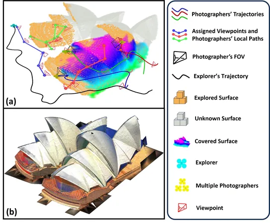
The Innovative Structure of SOAR
SOAR takes a revolutionary approach by employing a heterogeneous team of UAVs: one 'explorer' drone outfitted with LiDAR technology for efficient environmental mapping, and several 'photographer' drones equipped with high-resolution cameras to capture intricate visual details. This collaborative interplay between drones serves a singular purpose: to produce stunning 3D models of their surroundings.
Optimizing Viewpoints and Workload
The UAV referred to as the 'explorer' navigates and maps its environment using a surface frontier-based strategy, accumulating data as it goes. The system then generates incremental viewpoints necessary for thorough surface coverage. The designated photographers subsequently visit these locations to collect rich visual data.
Zhang explained, 'The viewpoints are systematically clustered and assigned using the Consistent-MDMTSP method, ensuring a balanced workload among the photographers while maintaining task consistency. Each photographer meticulously plans the most efficient path to capture images from the assigned vantage points.'
Dual Capability for Enhanced Reconstruction Quality
What makes SOAR truly groundbreaking is its dual capability to incorporate both LiDAR and visual sensors, leading to enhanced exploration and superior reconstruction quality. Zhang emphasized, 'Our system dynamically adapts to changing scene information, optimizing viewpoint coverage while minimizing unnecessary detours for the photographer drones.'
Promising Results and Future Applications
The researchers conducted numerous simulations to validate their approach, with promising results indicating that SOAR outperformed existing state-of-the-art techniques in environment reconstruction — a sentiment echoed by Zhang in stating, 'Our framework for rapid autonomous aerial reconstruction represents a critical advancement, employing innovative algorithms that balance real-time planning with overall operational efficiency.'
Potential Impact on Disaster Recovery and Urban Mapping
Looking ahead, SOAR could fundamentally change how we tackle pressing real-world challenges. Its potential applications include crafting detailed 3D models of urban landscapes, aiding in cultural preservation by reconstructing historical sites, and supporting disaster response efforts through quick visual assessments of damaged infrastructures.
Zhang remarked, 'SOAR could significantly aid disaster recovery operations by enabling responders to swiftly evaluate the aftermath of natural disasters, thereby efficiently orchestrating rescue missions and recovery efforts.'
Future Research Directions and Innovations
Additionally, this cutting-edge system holds promise for the inspection of construction sites and could revolutionize the creation of immersive video game environments inspired by real-life geography.
The researchers are brimming with enthusiasm about future research pathways. Plans include addressing the Sim-to-Real Gap — overcoming challenges associated with the translation of SOAR's capabilities from simulation to actual environments by resolving issues like localization errors and communication glitches.
Future studies will also focus on enhancing task assignment strategies to bolster UAV cooperation and optimize mapping speeds. With aspirations to include scene prediction and real-time feedback mechanisms during the reconstruction process, SOAR is on the brink of an even greater transformation, aiming to refine planning and maximize the quality of captured images.
Conclusion and Future Prospects
The ambitious goals laid out by Zhang and his team represent a thrilling frontier for autonomous UAV technology and could redefine the landscape of 3D environmental reconstruction — a leap into the future where drones and advanced algorithms work hand in hand to shape our understanding of the world!


 Brasil (PT)
 Canada (EN)
 Chile (ES)
 España (ES)
 France (FR)
 Hong Kong (EN)
 Italia (IT)
 日本 (JA)
 Magyarország (HU)
 Norge (NO)
 Polska (PL)
 Schweiz (DE)
 Singapore (EN)
 Sverige (SV)
 Suomi (FI)
 Türkiye (TR)